- Best Car Rental in Iceland")


Iceland is renowned worldwide for its breathtaking waterfalls, many of which are fed by glacial meltwater. No matter where you travel on the island, you’ll find incredible cascades to admire and photograph like Glymur. And the best part? With a rental car from Cars Iceland, you can explore them at your own pace, stopping for hikes and hidden gems along the way.
So, fasten your seatbelts (metaphorically, of course) as we embark on a journey to unveil the secrets of Glymur and discover why it's an absolute must-see in Iceland.
Glymur Falls Info
Glymur is Iceland’s second-highest waterfall, standing at 198 meters (650 feet). Located in West Iceland, it is fed by the river Botnsá, which runs from Hvalvatn lake and eventually reaches the Atlantic via the fjord Hvalfjörður.
There is a mythological story surrounding the waterfall, concerning magic and a whale. The story goes that a man was transformed into a whale by his angry elf former-lover. The man-turned-whale lived in Hvalfjörður (“Whale Fjord”) and attacked ships in Faxaflói bay. A priest lured the whale up Botnsá river. It swam up Glymur and into Hvalvatn (“Whale lake”), where it died.
How Do You Pronounce Glymur?
So, how do you pronounce Glymur? It might seem a bit tricky, but fear not! It's pronounced as 'GLUH-moor.' Don't worry; many people have stumbled over this one. Some common misconceptions include 'Gly-mur' or 'Gleemer.'
To remember the correct pronunciation, think of 'Gluh'as the sound you make when you're enjoying a warm cup of cocoa and 'moor' as in a mysterious, mist-covered landscape. So, put them together, and you've got 'Glymur. If you're curious about more intricacies of the Icelandic language, Glymur is a fantastic example of its unique sounds.
Driving to Glymur – What Rental Car Drivers Need to Know
From Reykjavik, it’s an easy drive to Glymur with a rental car. The journey is about 70 km (43 miles) and takes just over an hour.
Driving directions:
- Leave Reykjavik via Route 1 (Ring Road), heading north.
- After about 30 minutes, take the right turn onto Route 47, which follows the stunning Hvalfjörður fjord.
- Continue for another 30 minutes until you see the sign for Glymur.
- Turn onto the access road and follow it for about 3 km to the parking lot.
Important tips for rental car drivers:
- The parking lot is gravel but accessible for all vehicle types.
- There are no gas stations or facilities at Glymur, so fill up your tank before leaving Reykjavik.
- If you’re visiting in late autumn or early spring, check road conditions at umferdin.is, as ice or snow can make driving trickier.
Best Time to Visit Glymur by Car
Summer (June–August) is the ideal season for a waterfall road trip in Iceland. The days are long, the weather is milder, and most trails are free of snow. If you’re visiting Glymur waterfall in the winter, stick to easily accessible routes. Before heading out, always check the weather forecast at vedur.is.
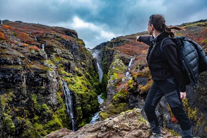
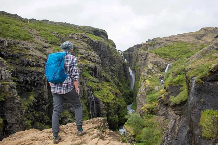
The Glymur Waterfall Hike
Glymur is only accessible by foot, but the hike is well worth the effort. The round-trip trail is about 7.5 km (4.7 miles) and mostly uphill. Expect a moderately challenging trek with river crossings, rocky paths, and spectacular scenery along the way.
How to Get to the Glymur Waterfall
When you arrive at the car park, the Glymur waterfall hike trail will be easily spottable. Signs and a gate mark the entry point; note that neither the car park nor the trail have any restrooms. Nature will be your bathroom for the next few kilometers. Follow the marked trail and you’ll soon come to a wonderful wide cave that the path passes through.
Shortly after you’ll reach your first river crossing. A thick wire provides support: hold on to that and carefully step between the rocks in the water. After the rocks is a log to walk across, and then you’re on the other side of the river. The rest of the hike is simply a case of continuing to follow the path.
It’s a journey of at least an hour and a half to two hours to the top. At the end of the Glymur falls hike, you are rewarded with the incredible spectacle of the waterfall itself. If you turn around, you’ll have a great view of the surrounding area. This hike has some tricky spots, so pay attention and come prepared.
The Way Back Down
The Glymur waterfall hike is more than just getting there; you have to get back down too. Once you’ve taken the time to appreciate the fall, hike above it until you come to the river that feeds it.
This river is fairly calm and not too deep, so fording it shouldn’t be a problem. Nevertheless, take care and pick your fording spot safely. Once you’re over to the other side, it’s a simple matter of following the path to the bottom. There is a junction at a certain point that gives you the choice between an easy or more difficult path. Either of these will take you to the car park where you started, creating a loop.
It’s a good idea to arrive at Glymur early so that you’re not walking back down in the dark. The summer months in Iceland have almost 24 hours of sunlight, so between June and August that won’t be a problem. Don’t forget your sunglasses and some sunscreen! Additionally, the hike is very popular, so if you start early in the morning you’ll avoid the crowds.
Essential hiking tips:
- Wear waterproof hiking boots, as you’ll need to cross rivers.
- Dress in layers and bring a waterproof jacket—weather changes fast in Iceland!
- Pack plenty of water and snacks. You can refill your bottle in the river.
- There are no restrooms along the trail, so plan accordingly.
The hike takes about 1.5 to 2 hours to reach the top. The views of the waterfall and surrounding landscapes make the effort worthwhile!
Can You See Glymur Without Hiking?
No, you can't see Glymur Waterfall without hiking. But hey, that's part of the charm! The Glymur Waterfall hike is a journey that rewards you with exclusive views you can't get from the roadside. It's like being part of an exclusive club where the membership fee is a bit of walking and a lot of awe.
While there's no shortcut to witnessing Glymur's majesty, the hike itself is dotted with viewpoints that offer a taste of its beauty without going all the way. These spots are fairly accessible, allowing you to soak in some stunning vistas of the surrounding landscape and feel the waterfall's misty breath from a distance.
What to Do Around Glymur Waterfall?
Glymur isn't just about the waterfall; it's your gateway to an Icelandic adventure in the Hvalfjordur area of West Iceland! Here are some must-see spots near Glymur so take your rental car in Iceland and get into action!
-
Settlement Centre of Borgarnes: Dive into Iceland's rich history, especially the captivating sagas and the birth of the nation. It's like a time machine to Iceland's past!
-
War and Peace Museum in Akranes: A fascinating look at Iceland during the 1940-1945 occupation period. History buffs, this one's for you!
-
Haafell Goat Farm: Get up close with Icelandic goats and learn about their conservation. It's not just educational; it's downright adorable.
-
Hraunfossar and Barnafoss Waterfalls: Just a stone's throw from Glymur, these waterfalls add more splash to your waterfall trail.
-
Deildartunguhver: Witness the power of Europe's highest-flowing hot spring. It's nature's own kettle on a grand scale!
-
Snaefellsnes Peninsula Excursions: Ready for a day packed with wonders? Visit Londrangar's basalt cliffs, Raudfeldsgja Gorge, the iconic Kirkjufell Peak, and Snæfellsjökull National Park.
Why We Recommend That You Visit Glymur Waterfall
We wholeheartedly recommend a visit to Glymur Waterfall – it's an experience that goes beyond just sightseeing. Imagine being surrounded by Iceland's raw, natural beauty, feeling the mist on your face, and hearing the thunderous roar of the falls.
The hike to Glymur is an adventure in itself, filled with breathtaking views and a sense of accomplishment as you reach the falls. It's not just a destination; it's a journey that stays with you long after you've left. So, pack your bags and see Glymur Waterfall for yourself. Trust us, it's an adventure you won't forget!
Ready for an Unforgettable Road Trip?
With a rental car from Cars Iceland, you can explore Iceland’s stunning waterfalls and hidden hiking gems on your own schedule. Whether you're chasing Glymur, Skógafoss, or Dynjandi, a reliable vehicle will help you make the most of your adventure. Book your car today and start exploring!